Driving to Cliffs of Moher: tolls, fuel & road trip guide
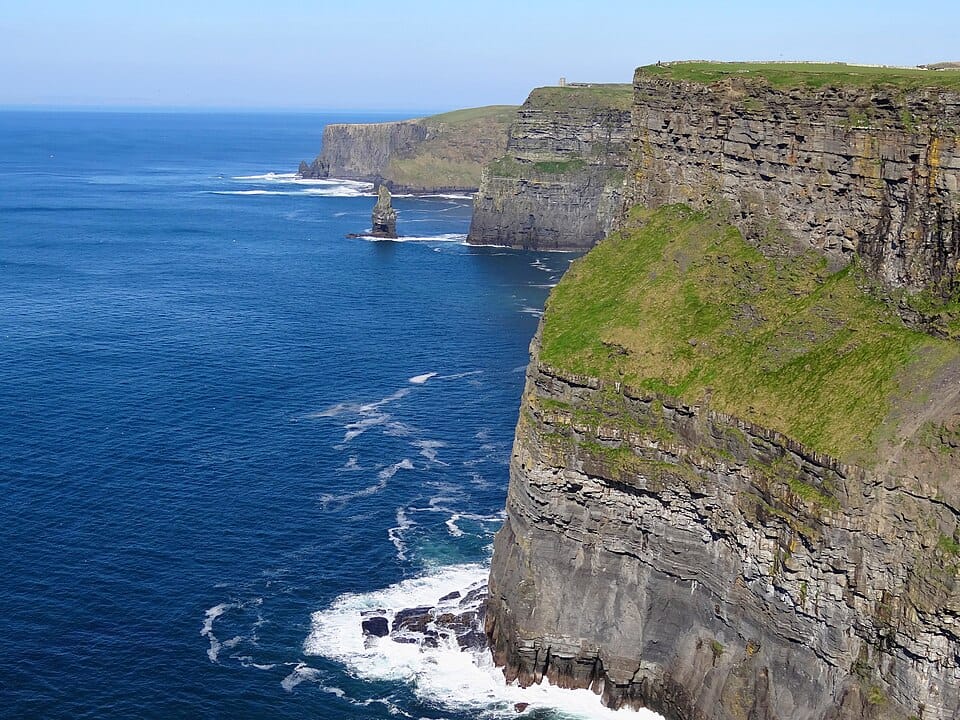
The Cliffs of Moher are sea cliffs on the southwestern edge of the Burren in County Clare, running for about 14 km along the Atlantic. They rise 120 m at Hag's Head in the south and reach their highest point of 214 m just north of O'Brien's Tower. With around 1.5 million visits a year they rank among Ireland's most visited sights, form part of the UNESCO-recognised Burren and Cliffs of Moher Geopark, and are a signature point on the Wild Atlantic Way; in peak season some 30,000 pairs of seabirds, including puffins, nest on the ledges.
From Killarney, many drivers head north and cross the Shannon Estuary on the Tarbert–Killimer car ferry instead of detouring inland via Limerick, then follow the Clare coast to the visitor centre on the R478 near Liscannor, where the official car park is. Arrive early or late in the day to avoid the coach crowds, and stay behind the walls and barriers: as of August 2026 parts of the coastal walk, including the stretch from Liscannor to Hag's Head, remain closed for safety. From here the road continues north through the limestone Burren to Galway, driving on the left.
Top attractions
O'Brien's Tower
A round stone tower built in 1835 by local landlord and MP Cornelius O'Brien as an observation point for visitors, standing near the cliffs' highest point with views to the Aran Islands and the mountains of Connemara on clear days.
Cliffs of Moher Visitor Experience
A visitor centre built into the hillside so as not to intrude on the landscape, opened in February 2007, with exhibitions on the cliffs' geology, history, flora and fauna, plus cafés and the official car park.
Hag's Head
The southern end of the cliffs, 120 m high, where an old promontory fort called Moher once stood and gave the cliffs their name; it was demolished in 1808 to build a Napoleonic-era signal tower above a large sea arch. The coastal path here is closed as of August 2026, so view it from the Southern Viewing Platform.
Doolin
A coastal village a few kilometres north of the cliffs, known as a centre of traditional Irish music played nightly in its pubs; from Doolin Pier, ferries sail to the Aran Islands and boat trips run beneath the cliffs.
The Burren & Poulnabrone Dolmen
A karst limestone landscape of about 530 km² just inland from the cliffs; its best-known monument, Poulnabrone, is a Neolithic portal tomb dated to around 3800–3200 BC and an easy stop on the drive north to Galway.
Driving to Cliffs of Moher
Road charges in Ireland
No motorway vignette or environmental sticker is required for passenger cars in Ireland; motorways are free or distance-tolled.
Driving distances from Cliffs of Moher
| To | Road km | Drive time |
|---|---|---|
| Galway | 55 | 47 min |
| Killarney | 132 | 1 h 53 min |
| Cork | 176 | 2 h 31 min |
| Kilkenny | 196 | 2 h 48 min |
| Dublin | 280 | 4 h 00 min |
Fuel prices in Ireland
Petrol 95 €1.97/L · Diesel €2.12/L (2026-09-28)
Plan your route with EuroDrive Scout →
Drive it on these routes
Nearby destinations
Cross-border destinations near Cliffs of Moher
- Lake District — United Kingdom, 586 km
- Glencoe — United Kingdom, 646 km
- Fort William — United Kingdom, 661 km
- Bath — United Kingdom, 667 km
- Edinburgh — United Kingdom, 678 km
- Portree — United Kingdom, 695 km